19 May 2010
Water Walks In Ripon - A Walk Along Borrage Lane
I have been spending a few minutes every day exploring the waterways of Ripon over the last month as part of some course work. It has been really enlightening and an abject lesson in what you can miss on your doorstep when you keep your eyes closed and your nose to the grindstone of daily toil.
The first thing that happened was that it was plain and simply good fun - just the beauty and a sense of excitement as you found new things. Secondly, Ripon really is a little gem of a city, forgotten and a bit tatty at the edges, but truly beautiful with countryside and farmland encroaching into the city. It's a green place, teeming with wildlife, and defined by its rivers.
Ripon is an old place. It's not Roman, but must have been inhabitated by local Britons before St Wilfrid rebuilt the monastery and cathedral of St Peter's & St Wilfrid's in the 7th century and that now defines and dominates the cityscape and skyline. But it's when you walk the rivers that you realise why Ripon was built where it is and why also it must have been inhabitated for many years prior to St Wilfrid.
There are three rivers that define Ripon - the River Laver, the River Skell and the River Ure (or in older times the River Yore which hints at its older pronunciation). All the rivers have their sources in the Yorkshire Dales. The Laver forms a border for Ripon on the west, meeting the Skell at the western edge of the old city and then the enlarged Skell flows through the centre of Ripon and where it used to form its southerly border. The Skell then flows out of the old city and meets the Ure at its eastern edge, before the Ure flows past Hewick Bridge and off to Boroughbridge. After a name change at Linton-on-Ouse, the Ure becomes the Ouse flowing through York, Selby and Goole before flowing into the Humber Estuary at Faxfleet and by England's largest tidal reedbed - Blacktoft Sands. The Ouse is the river of North Yorkshire and York is the second city of England.
So the three rivers create natural boundaries to the old city on the west, south and east. Then you have the low lying hill by the Skell, where Ripon Cathedral now sits and would have allowed you to watch over the shallow valley in all directions. The rivers are also flooding rivers and the area south of the Skell, where the canal and Dallamires Lane is located, would have been wet and boggy land, further protecting the city, while the surrounding land is good farmland that was mentioned in the Domesday Book.
So Ripon would just have seemed a great location to start a new settlement and I cannot believe that monks were the first people to notice this at the comparatively late date of 650AD.
Back to the walk, I started on Borrage Lane by Borrage Bridge and wandered along this small lane that has houses backing onto the River Skell and must regularly get flooded. There's a house here with a plaque stating that Wilfred Owen, the war poet, stayed here when recuperating in Ripon in March 1918 before going back to France and the trenches and death literally days before Armistice Day on 4 November 1918; how peaceful and idyllic Ripon must have seemed then and how dirty, noisy and cruel the war must have seemed as a distant memory only for him to have to return. In his famous collection of "War Poems and others", it states in the preface: "having much free time outside the camp, took a room in a cottage near the river where he could work in peace. In this pleasant retreat, poems begun earlier were heavily revised and new pieces written." He decided to go back to the front when Siegfried Sassoon was injured with a head-wound and parting in September wrote presciently to his mother "When I go from hence let this be my parting word, that what I have seen is unsurpassable." Because of him, we should all have etched onto our hearts the last 4 lines of one of his greatest poems:
"My friend, you would not tell with such high zest
To children ardent for some desperate glory,
The old Lie: Dulce et decorum est
Pro patria mori."...And yet we still go to war for glory!
At the top of Borrage Lane just before it curves northwards, I followed the path onto a green swathe that acts as a water meadow along the River Laver and wandered up to Laver Weir by Bishopton Bridge. Here, I watched the water pouring over the weir - quite mesmerizing and peaceful.
There used to be a dam here by the bridge called High Cleugh Dam, which diverted water along a Mill Race that went down the middle of Mallorie Park Drive, Skellbank and Low Skellgate all the way to a duck pond at the bottom of Duck Hill, before flowing back into the Skell by Bondgate Bridge. A cleugh means a cleft with water running through it, which is exactly what this is! There's a memory of these mills outside the Hugh Ripley Hall where two millstones are placed in the steps up into this community hall; this was the site of the High Mill. These mills declined after the High Cleugh Dam was destroyed in a flood in 1892 ending the flour mills of High Mill, Duck Hill Mill and Union Mill. In fact prior to then even, Ripon used to be the centre for textiles of the north before Halifax took over in the sixteenth century and Ripon entered centuries of economic stasis. Also, a bit further down river, there is more of the mill race on the north side of the Skell by Alma Weir, but more of that another day.
I pootled back down the River Laver to where it meets with the River Skell by Borrage Lane and wooden bridge that crosses over the enlarged Skell. This is a great place to play pooh sticks, but today I was more intrigued by where some steps up a bank by the Skell would lead to and where the path on the south side of the Skell came out back in Ripon. Anyway, the steps led to a field which takes you back to Whitcliffe Lane and the houses in that area plus Ripon Cathedral Choir School, while the path is a short walk back to Borrage Green Lane and a playground that was donated to the children of the city in 1930 by the widow of the last Williamson of the now converted varnish factory by Borrage Bridge in the centre of town.

If you were to walk across the field and then along Whitcliffe Lane now (May 2010), you will firstly see Ripon Cathedral Choir School which provides the beautiful young male and female voices for the sadly, hardly supported singing within Ripon Cathedral; it's such a waste of talent that no-one listens to Evensong every evening or the sung services in Ripon Cathedral as the talent is amazing for such a small area that is Ripon. Also, you should have a nosey at the school's main building as this was the former finishing post stand for Ripon Race Course for many years - it's actually back to front, i.e. the front of the school is actually the back of the stand; this was Ripon Race Course's second location, with the first by the Ure on the far side of North Bridge. This year and further down Whitcliffe Lane, you will see a quaint ceremonial gas lamp outside one of the houses and this is where the current Mayor of Ripon lives and is inscribed with the words "The Right Worshipful Mayor of Ripon", and moves around dependent on the current appointee.
It is amazing how green and interlocked with nature this part of Ripon is - farmland cuts behind Whitcliffe Lane and the Skell all the way up to the centre of the city by Borrage Bridge, while modern housing creeps ominously close but has not yet removed this belt of green. Then on the south side of Borrage Lane you walk among trees and the appetising aroma of wild garlic - masses of wild garlic and other riverbank plants. Ducks swim with their young broods of 4 or 5 ducklings, and the swallows dive and dance in the skies above the farmland. Save for the constant drone of cars, buses and lorries in the background, you would never believe that you were literally just feet away from urban life - albeit rural city life.

Also, you can see why Borrage Lane floods regularly - its banks are lower than those on the south side by about 2 or 3 metres, while the riverbanks have suffered erosion, especially close to Borrage Bridge. Also, like many rivers the Skell is deceptive - small, gentle flowing for most of the year, it will suddenly fill up as rainfall and snowmelt rush into it from the moorlands into the Laver, Kex Beck and Skell, all merging quickly and simultaneously in central Ripon to create a rapidly formed flood head that finds the lowest and weakest place to break the banks. The first place to go for these flood waters to find some freedom is Borrage Lane.

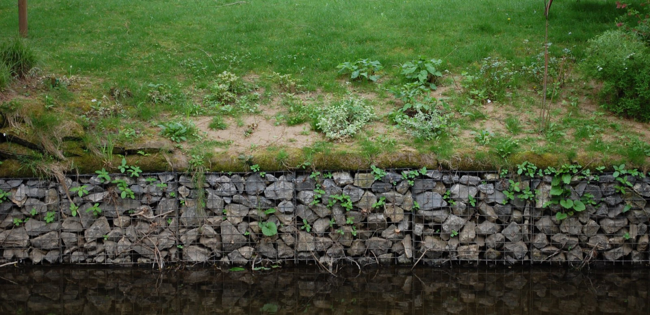
Most of the flood protection is home made concrete and solid walls, but nearer to Borrage Bridge gabions have been put in that create a softer edge to the riverbanks that also allows river life to flourish.
And there is loads of river life right here in the centre, and on the edge, of the city - wild garlic, ducks and ducklings, fish (like grayling, brown trout and salmon are slowly wending their way further up the tributaries of the Ouse), native crayfish, bats, skylarks, swallows and supposedly lampreys, water voles and sometimes otters. This is a part of England that is coming back to life as the countryside is cleaned up and people stop exploiting and fighting with nature, and letting it co-exist with us, enriching our lives.